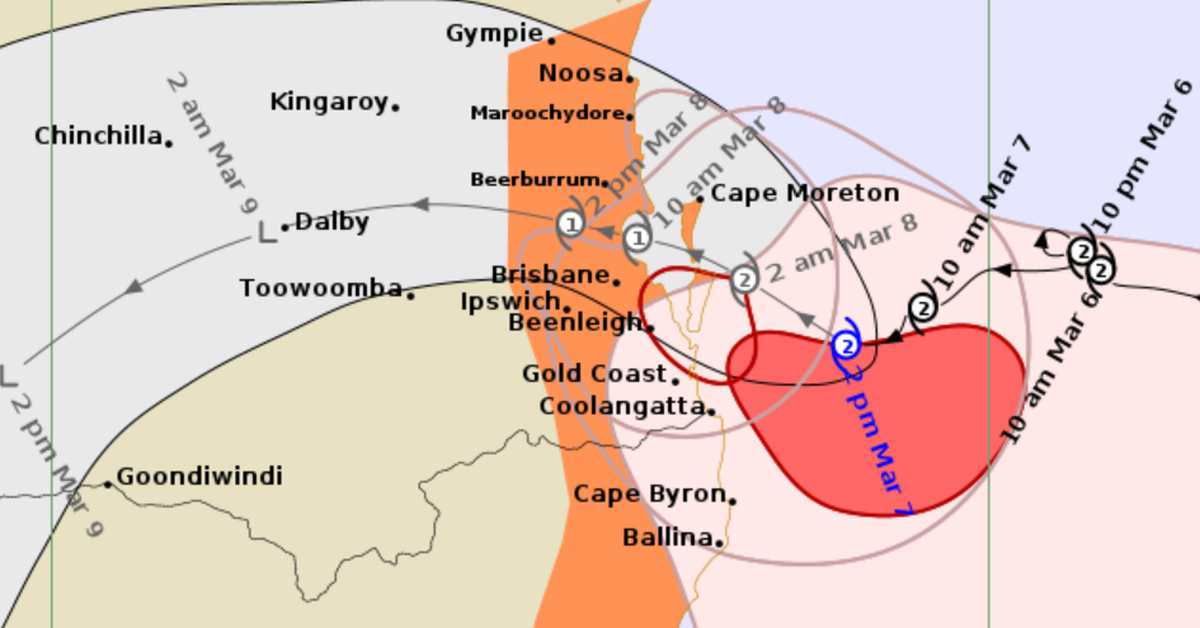
Tropical Cyclone Alfred is poised to make landfall in south-east Queensland and northern New South Wales on Saturday morning, bringing concerns of severe winds, heavy rain, and flooding. The cyclone has been moving slowly, which may prolong its impact as it reaches the coast, with estimates suggesting the crossing could last between six to nine hours.
Currently situated approximately 125km east-south-east of Brisbane and 90km east-north-east of the Gold Coast, Alfred has recorded sustained winds of up to 100km/h and gusts reaching 140km/h. Although landfall is anticipated tomorrow, residents in affected areas are already experiencing rainfall, abnormally high tides, and damaging surf, which have caused coastal erosion from Double Island Point to Grafton and beyond. The Bureau of Meteorology (BOM) has issued warnings of dangerous flash flooding likely to begin later today.
Damaging winds have already caused some trees to fall overnight, with gusts near the coastline reaching 120km/h. Areas around Cape Moreton and Yamba may experience even stronger gusts of up to 155km/h, particularly on the Moreton Bay Islands and exposed northern Gold Coast beaches. Evacuation orders have been extended, advising individuals in these regions to stay indoors and take precautions.
Forecasts predict that as Cyclone Alfred makes landfall on Saturday morning, wind gusts could still reach up to 155km/h. Although it may weaken to a category 1 cyclone as it moves inland, the threat of heavy rainfall and damaging winds will continue into the weekend. Some areas in both south-east Queensland and northern New South Wales could see rainfall totals exceeding 200mm in six hours, with certain regions projected to receive up to 400mm within a 24-hour period. This rainfall is particularly concerning for low-lying areas already at risk of flooding.
By Sunday, it’s expected that Alfred will lose its tropical cyclone classification but may still deliver significant rainfall, especially in flood-prone regions. Additional rain is also forecast for southern areas like Sydney and the Australian Capital Territory over the coming days, heightening the risk of further flooding.
Residents are advised to stay updated with information from the Bureau of Meteorology and to prepare for severe weather conditions as Cyclone Alfred approaches the coast. Safety precautions are critical as the storm system moves inland, potentially impacting many communities across the regions.